



A workflow for deriving jurisidictional risk-allocated deforestation mapping compliant with Verra’s VMD0055 (V1.1) module and the VM0048 (V1.0) consolidated methodology. This includes baseline estimates of forest change and jurisdictional allocated deforestation.
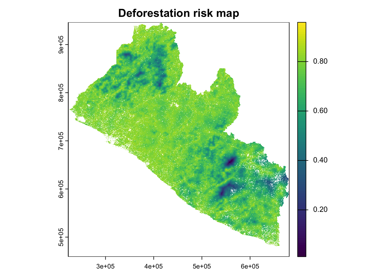
This assessment develops a spatially explicit deforestation risk map and allocation framework for Bong County, Liberia, following Verra’s VM0048 methodology requirements. The analysis integrates the baseline emissions estimates developed in the previous workflow with spatial risk modeling to allocate jurisdictional deforestation across the landscape based on empirically-derived risk factors.
This analysis maintains consistency with the baseline emissions assessment by focusing exclusively on Bong County (8,772 km²), located in west-central Liberia. The county encompasses diverse forest-agricultural landscapes within the Upper Guinea Forest biodiversity hotspot, representing typical West African deforestation pressures including:
Agricultural expansion (primarily rice and cassava)
Small-scale logging and charcoal production
Road development and settlement expansion
Mining activities (iron ore and artisan mining)
2. Method
Four-step process:


Covariate Development: Process infrastructure, demographic, and biophysical risk data layers
Statistical Evaluation: Check covariate magnitude to historical deforestation
Model Development: Empirically weighted risk model generation
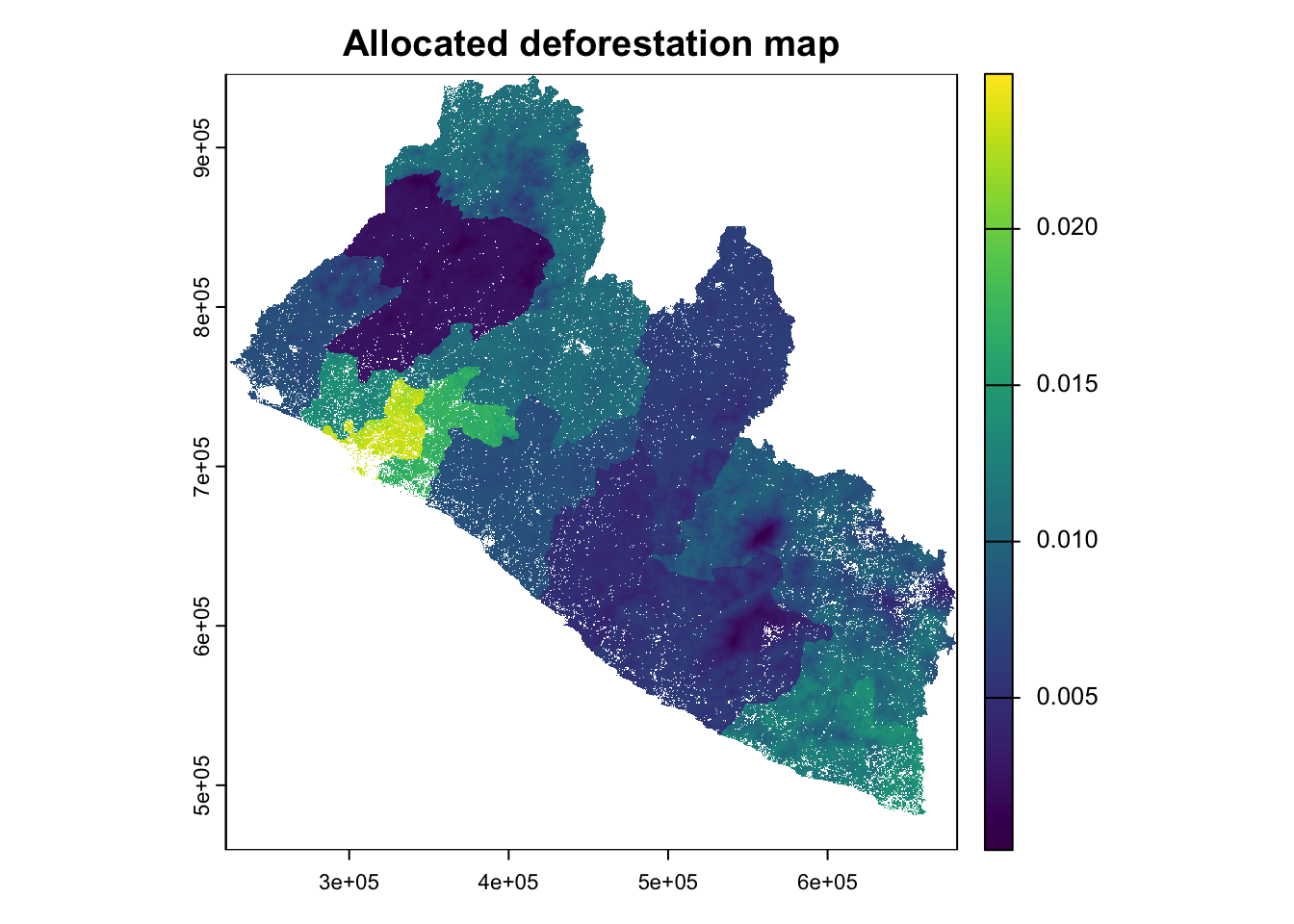
Deforestation Allocation: Spatial distribution of baseline deforestation rates based on risk surfaces
# Import & reproject to OSM grid systemsaoi_country = geodata::gadm(country="LBR", level=0, path="./assets/AOI") |> sf::st_as_sf() |> sf::st_transform("EPSG:3857")aoi_states = geodata::gadm(country="LBR", level=1, path="./assets/AOI") |> sf::st_as_sf() |> dplyr::filter(NAME_1 =="Bong") |> sf::st_transform("EPSG:3857")crs_master = sf::st_crs(aoi_country)# Total extentarea_km2 =as.numeric(sf::st_area(aoi_states)) /1e6cat("Study Area: Bong County, Liberia\n")
In Liberia, the official definition of forest land is provided by the Forestry Development Authority (Government of Liberia 2019), including areas of land that meet the following criteria:
Canopy cover of minimum 30%;
Canopy height of minimum 5m or the capacity to reach it;
The following spatial covariates were processed as potential drivers of deforestation risk. Covariates were merged between sociodemographic and geographic datasets surrounding the project area and national level datasets beyond the project area in order to enable jurisdictions analysis.
Two methods were explored for weighting variables and creating a generalized deforestation risk index. We could consider developing a spatial risk model using the spatstat package or logistic regression, as has been cited in recent Verra guides. In addition, some of the heavy lifting with input formatting and data wrangling has already been completed.
However, spatial modelling has tended to produce challenges when fitting such large country-wide covariates. Moreover, these kinds of spatialy driven models tend to require longer training procedures due to their intercept-based spatial kernels and slower resampling patterns.
Alternatively, we have drafted a tentative risk indexing approach based on a weighted sum of subjectively scored covariate effects. While each variable would still need a carefully reasoned score, this option offers a more streamlined method that is easier to adjust. We applied this risk index to inform a risk weighted allocation of the 10-year deforestation rate, first by multiplying the fraction of pixel risk by zonal forest loss, and second by factoring out annual zonal loss by multiplying by pixel risk values, as shown below
Both formulas describe the same operation in different orders of multiplication: each pixel in a given zone Z receives a share of annual_loss_10yrZ based on its proportional risk (the pixel’s risk relative to the sum of all pixel risks in that zone). This ensures that higher-risk pixels are allocated more deforestation, in line with the Verra guidance for an allocated deforestation risk map.
We intend to present both of these approaches for broader review and discussion in our upcoming meeting.